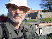
Being retired since the beginning of this year, I was pretty enthusiastic to be able, at last, to set out on longer hikes than my previous ones, limited to the holidays.
So, last week, I flew to Bristol in order to embark on a 12 days hike along the South West Coast Path, from Padstow (Cornwall) to Minehead (Somerset) (270 km).
Unfortunately, at the end of the third leg, I didn't feel well at all. I don't know if it was due to the effect of the oceanic iodine (I suffer of a light hyperthyroidism) or to the exhaustion (it is a really tough path) or a combination of both or whatever.
I was a bit concerned about the symptoms and, anyway, I didn't feel in the mode to continue the trip any further. Thus I went to Bristol and flew back home.
On the whole I walked a little bit more than 50 km, from Padstow to Crackington Haven, stopping in Port Isaac, Tintagel and Crackington Haven.
I must confess that although the coast was pretty gorgeous, I am afraid that after a few more days I would have found it a bit monotonous.
I found the North Cornish Coast rather similar to Pembrokeshire (I mean the coastal landscape) but more affected by tourism. So, even if Cornish villages are definitely nicer than Welsh ones, I liked better the Pembrokeshire Coast Path: I am keen on unspoilt area.
Mind you, gentle reader, the SWCP is really very tough. The coast is generally high but, at any stream (and there are so many), the path drops abruptly down to sea level and then rises steeply again. But what makes it definitely exhausting is the shape of the path. Very often, instead to go up and down in hairpin way in order to have a more gradual ascent it goes straight on and, moreover, often through very high steps. The knees get hurt going down and the muscles strain quite hard during the ascent.
ABOUT THE GEAR
The main difference between the gear I carried in this last hike and that of the previous one (see Cévennes) concerns mattress and rucksack. I replaced the closed cell foam mat (Z-Lite) with an air mattress (Thermarest Neo Air) which is about the same weight but, being very compact when deflated, has the advantage to fit in a smaller and lighter rucksack. So I replaced the Golite Jam-2 rucksack (51 l. and 700 g.) with Gossamer Gear Murmur (35 l. and 202 g.) which, besides being pretty lighter, is definitely more comfortable because its better weight distribution.
Moreover, in my quest for the ideal ultralight walking, I saved some more weight dropping mug, fuel, lighter and instant coffee: studying the map I realized that even if I had to camp I could soon find a place where to have a coffee in the morning; which for me is sacrosant.
But although I saved some hundreds of grams, eventually, the total weight I carried was nearly the same as that of the previous hike. In fact, having planned to walk many more days I carried much more food.
A doleful remark: my Innov-8 Rocklite 318 GTX trail shoes have once again revealed some flaws.
Firstly one cushion collapsed on the inner side causing a light inflammation to the foot and the ankle.
Secondly, although due to their Goretext membrane they are advertised as waterproof, after about two hours of moderate rain my feet were thoroughly soaked. Luckily, at the inn where I stayed, the heating was working!
So if there is any walker luckier than myself in finding a really waterproof light shoe, I beg him to tell me about it.
PROJECTS
I have already organized for next August a six day hike along part of the Ridgeway and the Thames path with my daughters and my wife.
For the next solos I am considering GR 7 Alpujarras section. I would like to go there when the almond trees are in blossom but I am wondering if in February, at about 1000 m., it is not too cold to camp. So, once again, if some gentle reader has been there, please tell me about.
In Autumn I would like to hike from Città di Castello (where I was born) to Florence (where I have spent the most important part of my life). There is not a well defined trail. One has to design it oneself and there are many choices about the route to follow.
One simple, but tough and probably not the most beautiful route is to climb to the top of the Apennines directly from Città di Castello (about 15 km.) and then follow the ridge up to Florence region where to drop into the city.
An other route, which seems to me more attractive, is to follow the river Tiber up to Monterchi than to pass by Anghiari, Caprese Michelangelo, Badia Prataglia, Vallombrosa. Then drop down to the stream Sieve from where to climb to Settignano. From Settignato it is possible to catch a bus for Florence or follow a large footpath with many steps which goes down to Rovezzano in the outskirts of Florence.


No comments:
Post a Comment